Direct answer: For line- or outline-inspired world map art, choose options that emphasize clean borders, readable labeling, and durable finishes. The top picks below are best for classrooms, study spaces, and decorative offices where map detail matters without overwhelming the wall. Each product is suited to different buyers—educators, students, interior decorators, and casual map enthusiasts will find a fit.
| Product | Best For | Why It Stands Out |
|---|---|---|
| Rand McNally Classic Edition World Wall Map | Classrooms, libraries, and offices | A large 50″ x 32″ map with antique accents and up-to-date political boundaries; Africa-centered projection reduces edge distortion. |
| 2 Pack – Laminated World Map Poster & USA Map Set (Equal Earth) | Homes and classrooms needing multiple, color-accurate posters | Two posters in 18″ x 29″ size with durable lamination; Equal Earth projection shows continents true to size. |
| Laminated Blank World Map Outline Poster (18″ x 29″) | Chalkboard-style learning and wet-erase activities | Clear outline world map with Miller projection; laminated for reusable marker use. |
| National Geographic World Wall Map — Executive | Educational decor and reference use | Authoritative design with antique palette; backed by National Geographic’s research standards. |
| United States and World Map For Kids Classroom Posters (2pc Set) | Kids’ classrooms and homeschooling | Bright, kid-friendly visuals; updated facts; engaging icons and landmarks for discussion. |
Rand McNally Classic Edition World Wall Map — 50″ x 32″ Laminated

- Features a classic décor that doubles as a reference map with up-to-date political boundaries.
- Color-matched topographical relief highlights major physical features for quick study.
- Africa-centered projection minimizes edge distortions and keeps continents intact.
Best for: Large rooms, libraries, and classrooms that want a sophisticated, durable wall map with reliable geography data. Limitations: Size may be large for small rooms; rolled, laminated format requires space during setup.
2 Pack – Laminated World Map Poster & USA Map Set – Equal Earth

- Set includes two posters, each 18” x 29”, designed with Equal Earth projections to reflect true-area sizes.
- Durable 3 mil lamination protects against dings and ink wear, suitable for high-traffic spaces.
- Better for shared spaces where multiple learning angles (physical size and relative area) matter.
Best for: Classrooms or family spaces needing more than one map with color-accurate size perception. Limitations: Smaller than large wall maps; may require multiple framing or wall space planning.
Laminated Blank World Map Outline Poster

- 18” x 29” world outline map with a Miller projection suitable for outlining and marking.
- 3 mil lamination offers a reusable surface for dry-erase markers or wet erase (as applicable).
- Best for instruction that emphasizes drawing paths, routes, or custom annotations.
Best for: Teachers and students who want to annotate routes, historical events, or project-specific regions. Limitations: Outline-only; lacks political labels for quick reference without added effort.
Histomap 4,000 Years of World History Timeline Poster

- A vertical 12″ x 48″ poster tracing civilizations across 4,000 years, offering a historical context to geography.
- Extra-large format is designed for classrooms and study corners that benefit from long-form timelines.
- Not a typical geographic map, but pairs well with geographic maps for integrated learning.
Best for: History-focused spaces where map-based timelines enrich curriculum. Limitations: It is a historical timeline rather than a strictly geographic map, so use alongside conventional world maps.
United States and World Map For Kids Classroom Posters
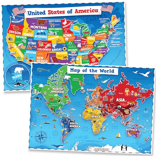
- Two posters in a kid-friendly style with updated facts and engaging icons for landmarks.
- Bright colors and clear typography designed for ages 4-8, supporting reading and geography discussions.
- Ideal for early-learning environments and homeschool settings that prioritize visual appeal and clarity.
Best for: Young learners and classrooms seeking approachable, visually engaging map decor. Limitations: Simpler labeling may not satisfy advanced geography needs.
Buying Guide
What to consider when choosing world map wall art:
- Projection and accuracy: Choose projections that minimize distortion in the areas you care about most, such as Africa-centered or Equal Earth for true-area representation.
- Size and space: Large formats require ample wall space and sturdy hanging options; smaller posters fit compact rooms or learning corners.
- Durability: Laminated surfaces resist wear in busy classrooms or kids’ spaces; dry/wet-erase compatibility matters for outlines and annotations.
- Labeling style: For quick reference, maps with clear country names and readable fonts work best in educational contexts; outlines are ideal for interactive activities.
- Aesthetics: Antique or executive palettes suit formal rooms, while bright, colorful designs suit classrooms and kids’ spaces.
- Multi-pack value: For homes or schools needing more than one map, bundles with complementary projections or themes can simplify decor decisions.
FAQ
- What map projection is best for classroom use?
– It depends on the learning goal. Equal Earth shows relative sizes accurately, while Africa-centered projections minimize edge distortions for Africa-focused studies. - Are laminated maps better for high-traffic rooms?
– Yes. Lamination protects the map and allows reuse with dry-erase markers, enhancing durability in classrooms. - Should I choose an outline map or a labeled map?
– Outline maps are ideal for annotation and activities; labeled maps help with quick reference and geography quizzes. - Can these maps be used in professional offices?
– Yes, select maps with classic or executive palettes to complement formal interiors while providing educational value. - Do these posters come with installation hardware?
– The product pages typically provide mounting guidance; consider wall hooks or frames suitable for the wall type.